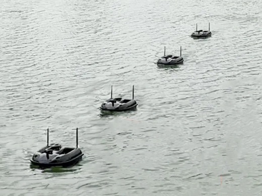
Marine robotic vehicles—including ROVs (Remotely Operated Vehicles), AUVs (Autonomous Underwater Vehicles), and USVs (Unmanned Surface Vehicles)—are transforming how we interact with our oceans. By integrating RTK-GPS, these drones achieve centimeter-level positioning for high-stakes maritime tasks.
Key benefits of precision marine robotics:
Accurate Mapping: Enables high-resolution seafloor mapping and bathymetric surveys with surgical precision.
Environmental Monitoring: Provides a cost-effective and eco-friendly way to study marine ecosystems without disturbing the habitat.
Infrastructure Inspection: Safely inspects underwater pipelines, cables, and bridge foundations with exact coordinate tracking.
Safe Exploration: Replaces human divers in dangerous or deep-water environments, reducing risk and operational costs.
Combining autonomous mobility with RTK accuracy ensures that subsea data is more reliable, detailed, and accessible than ever before.
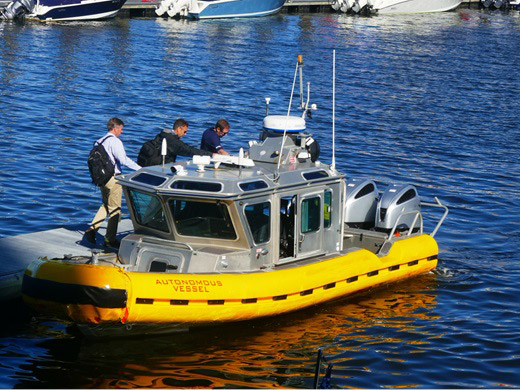
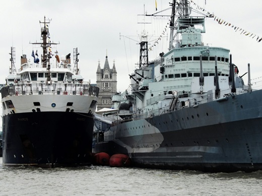
Just as the automotive world moves toward self-driving cars, maritime engineering is launching autonomous, skipperless ships. Powered by the synergy of RTK technology and Artificial Intelligence, these vessels are set to revolutionize global shipping by maximizing safety and operational efficiency.
The impact of RTK-driven autonomous vessels includes:
Precision Navigation: RTK provides the centimeter-level accuracy needed for complex maneuvers in congested ports or narrow channels, even in challenging conditions.
Hazard Avoidance: Integrated AI systems process real-time data to detect obstacles and optimize routes without human intervention.
Extreme Mission Capability: These ships are ideal for tasks deemed too risky for human crews, such as navigating through extreme weather or transporting hazardous materials.
Efficiency & Sustainability: Autonomous systems reduce human error (the cause of most maritime accidents) and calculate the most fuel-efficient paths to lower emissions.
By removing the limitations of human fatigue and visibility, autonomous maritime technology ensures a more reliable and productive future for the international shipping industry.
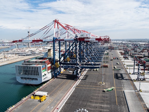
Automating heavy port machinery, such as reach stackers and straddle carriers, is a cornerstone of modern smart terminals. To maintain high-speed operations, these vehicles require constant, precise positioning, even in the “urban canyons” created by shipping containers.
The advantages of GNSS/INS integration in ports include:
Uninterrupted Positioning: By combining GNSS with Inertial Navigation Systems (INS), machinery maintains its coordinates during signal losses, such as when driving under a crane.
Reliable Connectivity: Multi-frequency receivers ensure a stable lock even when direct sky visibility is partially obstructed by stacked containers.
Magnetic Interference Shielding: Unlike traditional magnetic sensors, which fail near massive metal structures, RTK-based systems remain accurate and reliable.
Enhanced Safety: Precise tracking of every moving asset reduces the risk of collisions in high-traffic container yards.
By utilizing GNSS/INS technology, ports can transition to fully autonomous workflows, ensuring 24/7 productivity with maximum operational security.
Septentrio: Reliable GNSS & GPS solutions for logistics & port operations
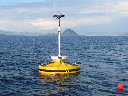
GNSS RTK buoys are essential tools for precise, real-time water surface monitoring and maritime surveying. Whether in the open ocean or near the coast, these systems provide the high-accuracy data required for modern hydrography.
The benefits of RTK-enabled buoys include:
Remote Data Collection: Capable of real-time kinematic and post-processing techniques, they operate effectively in remote areas far from land-based stations.
Coastal Resilience: By utilizing cost-effective RTK receivers, ports can deploy high-accuracy networks that are easier to maintain in high-risk coastal zones.
Continuous Monitoring: Ensures centimeter-level accuracy for tracking sea levels, wave heights, and tides, which is vital for navigation safety.
Environmental Research: Provides stable, high-precision data points for long-term climate and ecosystem monitoring.
By integrating RTK technology, maritime authorities gain a reliable, real-time window into the changing conditions of our oceans and waterways.
🔗Development of GNSS Buoy for Sea Surface Elevation Observation of Offshore Wind Farm
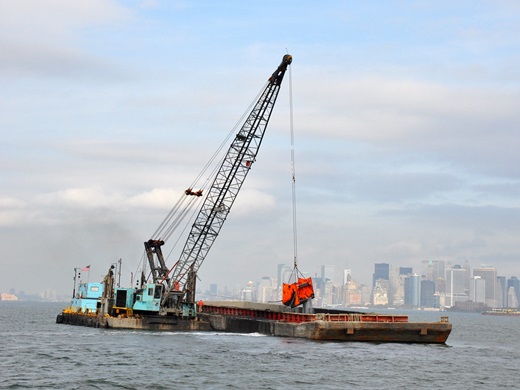
RTK network technology is essential for the success of dredging and underwater construction projects. By providing exact underwater positioning, it ensures that heavy equipment is placed and operated with centimeter-level accuracy, even when the work site is hidden beneath the surface.
The impact of RTK-integrated dredging includes:
Surgical Placement: Enables the precise positioning of dredging heads and equipment, ensuring excavation happens exactly where planned.
Environmental Protection: Minimizes unnecessary seabed disturbance, which is crucial for conserving sensitive marine ecosystems.
Real-Time Adjustments: Allows operators to make instant corrections based on live coordinate data, improving the overall quality of the build.
Efficient Execution: Streamlines the work process, reducing the number of passes needed and saving time and fuel.
By utilizing RTK GPS, underwater contractors can transform complex marine engineering into a highly controlled and efficient operation.
Septentrio: Robust offshore dredging operations thanks to anti-jamming technology
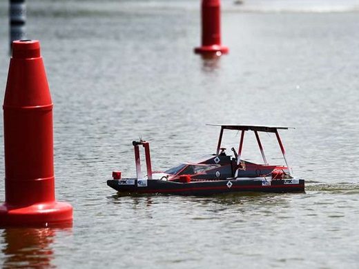
The use of unmanned vehicles powered by RTK technology represents a major leap in sustainable fishing. By utilizing advanced sensors and centimeter-level positioning, these autonomous systems can locate krill and fish stocks with unprecedented accuracy.
The benefits of RTK-driven detection include:
Resource Conservation: Precise location data helps fishing crews target specific areas, minimizing unnecessary fishing activity and protecting marine ecosystems.
Emission Reduction: By eliminating the need for large boats to aimlessly search the ocean, the system drastically reduces fuel consumption and carbon emissions.
Economic Sustainability: Cutting down on search time translates to significant time and cost savings for the fishing industry.
Data-Driven Management: Provides high-quality data that aids in long-term conservation and resource management strategies.
Integrating RTK precision into maritime scouting transforms traditional fishing into a highly efficient, eco-friendly operation.
ArduSimple: Exploring fish habitats and reefs with scan sonar and ZED-F9P RTK receiver
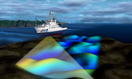
RTK GPS technology has revolutionized hydrographic surveys by providing centimeter-level accuracy. This precision is the foundation for creating high-resolution seafloor maps and ensuring the integrity of underwater data.
The impact of RTK-integrated survey boats includes:
Tide Gauge Elimination: RTK provides real-time, precise water level corrections, removing the need for traditional, labor-intensive tide gauges.
Automated Navigation: Smart features allow boats to hold position or follow pre-set paths autonomously, ensuring 100% coverage of the survey area.
Superior Data Quality: Extreme positioning accuracy allows for the detection of minute changes in underwater terrain and submerged structures.
Operational Efficiency: Purpose-built vessels handle water-specific challenges, making data collection significantly quicker and more reliable.
By combining autonomous mobility with RTK precision, surveyors can explore and document underwater environments with unprecedented detail and efficiency.
Biofouling—the accumulation of marine growth on ship hulls—is a major challenge for the maritime industry, leading to increased drag, higher fuel consumption, and elevated pollution levels. RTK-powered cleaning robots provide a high-precision, automated solution to keep vessels performing at their peak.
The advantages of RTK-integrated cleaning robots include:
Precision Navigation: RTK provides the centimeter-level tracking necessary for the robot to cover every inch of the hull systematically without missing spots.
Advanced Cleaning Tech: Using a combination of rotating brushes and high-pressure water jets, these robots securely attach to the ship via negative pressure vortices to remove growth safely.
Fuel & Emission Savings: Regular, automated cleaning ensures a smooth hull, leading to significant fuel savings and a reduction in the ship’s carbon footprint.
Automated Maintenance: Replaces dangerous and time-consuming manual diving inspections with a safe, efficient, and autonomous process.
By adopting RTK-driven automation, the maritime industry can ensure optimal vessel performance while drastically minimizing its environmental impact.
🔗Algorithm for Determining the Position of a Ship Hull-Cleaning Robot
RTK technology is revolutionizing the way moored ships are managed and monitored. By providing centimeter-level accuracy, these systems allow operators to measure a vessel’s subtle movements in real-time, providing a scientific basis for port safety and logistics.
The key advantages of RTK for moored vessels include:
Dynamic Movement Analysis: High-precision data tracks how waves, currents, and wind affect a ship’s position, allowing for a detailed understanding of its behavior in various marine conditions.
Safe Operating Thresholds: By analyzing movement patterns, port authorities can define exact safety limits and better prepare for adverse weather events.
Heading Precision: Knowing a ship’s exact heading is critical during the mooring process to ensure precise docking, effectively minimizing the risk of collisions or structural damage to the pier.
Enhanced Safety Protocols: Integrating RTK GPS into monitoring systems represents a major leap forward in maritime risk management, ensuring ships stay securely positioned throughout their stay.
By moving from visual estimation to data-driven monitoring, maritime operators can enhance both the safety and the efficiency of port operations.
Septentrio: Top 3 Positioning Challenges in Autonomous Marine Navigation
Ensuring the security of ports and harbors presents a challenging and costly endeavor. Monitoring extensive maritime areas for potential threats requires advanced technology. GNSS RTK solutions, combined with sensor fusion technology, empower security teams to establish temporary security zones around critical assets such as ships and containers. This setup enables the swift detection and reporting of unauthorized movements or changes, bolstering port security.Securing ports and harbors is a complex and high-stakes challenge. By combining GNSS RTK solutions with sensor fusion technology, security teams can move beyond traditional surveillance to create a dynamic, high-precision defense network.
The core benefits of RTK-driven port security include:
Temporary Security Zones: Quickly establish high-precision virtual perimeters (geo-fences) around specific high-value assets, such as tankers or sensitive container shipments.
Instant Threat Detection: The system provides the centimeter-level accuracy needed to detect even the slightest unauthorized movement or tampering in real-time.
Sensor Fusion Integration: By merging RTK data with cameras, radar, and AIS, security teams gain a unified operational picture, reducing false alarms and improving response times.
Scalable Monitoring: Offers a cost-effective way to monitor extensive maritime areas where traditional physical barriers are impractical or impossible to install.
By leveraging RTK precision, harbor authorities can transform passive monitoring into a proactive security shield, ensuring the safety of global trade hubs.
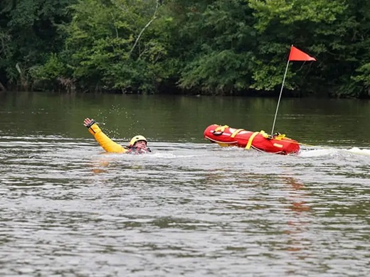
In critical emergency situations, water rescue robots provide a rapid and life-saving alternative to traditional methods. Designed for immediate deployment in seas, lakes, and rivers, these autonomous or remote-controlled units reach victims in a fraction of the time it takes for a human team to mobilize.
The advantages of RTK-enhanced rescue robots include:
Centimeter-Level Accuracy: With RTK positioning, robots can navigate directly to the exact coordinates of a distress signal, even in low visibility or choppy waters.
Rapid Deployment: Engineered for speed, these robots can be launched from shore or vessels to assist individuals in inaccessible or hazardous areas quickly.
Rescuer Safety: Operates on the water’s surface to perform high-risk tasks, keeping human rescuers out of danger during extreme weather or in treacherous currents.
Advanced Detection: Equipped with sensors and cameras, the integration of RTK data ensures that the location of found individuals is shared with emergency teams with absolute precision.
By combining autonomous speed with RTK precision, emergency services can maximize the efficiency of search and rescue operations, ultimately saving more lives while minimizing risk to personnel.
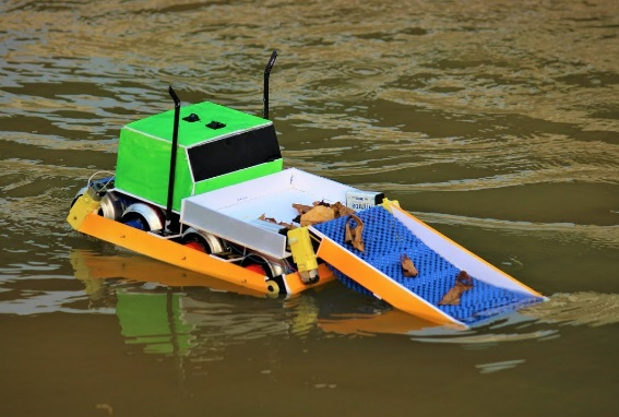
Water surface cleaning vessels, whether remotely piloted or fully autonomous, represent a breakthrough in maintaining the health of lakes, harbors, and industrial facilities. These uncrewed surface vessels (USVs) are engineered to act as the frontline of defense for aquatic ecosystems.
Key capabilities of RTK-equipped cleaning robots:
High-Capacity Waste Removal: Efficiently collects floating solid waste and debris from marinas and reservoirs with centimeter-level navigation to ensure full area coverage.
Pollution Control: Specialized systems allow these vessels to manage and remove hydrocarbon spills, preventing long-term environmental damage.
Ocean Restoration Missions: Deployed globally to tackle complex challenges like microplastics filtering and large-scale waste removal in open waters.
Biodiversity Analysis: Beyond cleaning, these robots serve as mobile data hubs, using precision positioning to conduct biodiversity surveys and monitor water quality.
By integrating RTK precision with high-capacity cleaning hardware, the maritime industry can automate the restoration of our waterways, making environmental cleanup faster, safer, and more.