When starting a research project or developing a prototype that requires precise positioning, GNSS/RTK technology is an essential component. The market currently offers a wide array of technical solutions designed to meet the rigorous demands of scientific and engineering innovation.
Key considerations for RTK-based research projects:
Multi-Frequency Receivers: These are vital for achieving faster convergence times and maintaining signal stability, which are critical for gathering accurate data in challenging environments.
Antenna Selection: Choosing the correct antenna is a decisive factor in maximizing satellite reception and minimizing multi-path interference for your prototype.
Cost-Effective Innovation: The evolution of GNSS hardware has made high-precision components more accessible, allowing researchers to implement centimeter-level accuracy in robotics, agronomy, and civil engineering without prohibitive costs.
Technical Specifications: Every project has unique constraints regarding weight, power consumption, and communication interfaces that dictate the choice of hardware.
By utilizing real-time correction data, researchers can focus on developing their specific applications with the confidence that they have a reliable, centimeter-level positioning foundation.

Developing projects that require outdoor high-precision positioning is a common challenge for those in Science and Engineering programs. Whether you are a student, a doctoral candidate, or a dedicated lab researcher, integrating centimeter-level RTK technology is key to pushing the boundaries of your field.
How Precision-GNSS supports research and innovation:
Tailored Guidance: Selecting the right hardware is crucial for a successful thesis or experiment. Precision-GNSS offers the necessary technical support and advice to help you choose the best tools for your specific use case.
Seamless Integration: High-precision modules are designed to be easily integrated into various platforms, from autonomous rovers to environmental sensors.
Accessible Technical Support: To ensure your project stays on track, basic technical support is available to assist with the integration and configuration of Precision-GNSS products.
Proven Results: Centimeter-level accuracy has already enabled breakthroughs in diverse research areas, including structural monitoring, autonomous robotics, and precision environmental mapping.
By leveraging Precision-GNSS technology, academic innovators can transform theoretical models into accurate, real-world applications with the reliability of professional-grade positioning.
Are you ready to take your Science or Engineering project to the next level with centimeter-level accuracy? Whether you are navigating the complexities of a doctoral thesis or building the next generation of autonomous prototypes, the right positioning foundation is critical.
Get Expert Guidance for Your Project: Our team understands the unique requirements of academic and laboratory environments. If you need assistance selecting the right hardware or integrating our modules into your specific setup, we are here to help.
[!TIP] Contact our Academic Support Team today to discuss your specifications and find the most cost-effective solution for your research.
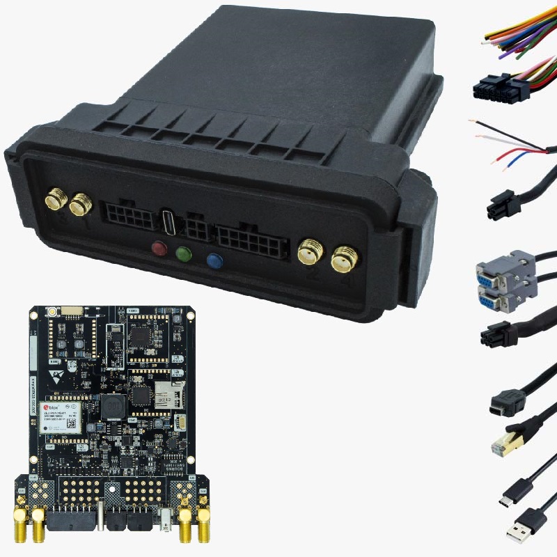
Implementing RTK Technology for scientific innovationHigh-precision components for robotics and engineering prototypes
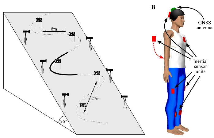
Competitive athletes win or lose races by fractions of seconds. In the sport of alpine ski racing, precise data of the center of mass (CoM) position, speed and acceleration are indispensable for the purposes of performance analysis and injury prevention.
The study examines a novel system involving a GNSS RTK that returns a reference trajectory through the use of a suit, imbedded with inertial sensors, to reveal subject segment motion.
The aims were: to measure and enhance performance, particularly in a sport like skiing that involves speed, distance and timing, precise knowledge of rate of descent, lateral accelerations, and gate crossing times is critical to analyzing strengths and weaknesses.
Or you need to provide guidance to the blind skier? Or runner? It is possible for visually impaired people to navigate the outdoor world, independently. In competitive alpine skiing, where races are won or lost by fractions of a second, athletes and coaches require more than just a stopwatch. Precise data regarding the Center of Mass (CoM) position, velocity, and acceleration is indispensable for elite performance analysis and injury prevention.
How RTK technology transforms sports science:
Precise Trajectory Mapping: By using a specialized suit embedded with inertial sensors and GNSS RTK, researchers can generate a reference trajectory that reveals exact segment motion.
Performance Metrics: Access critical data on rate of descent, lateral accelerations (G-forces), and gate-crossing times to identify an athlete’s technical strengths and weaknesses.
Injury Prevention: Monitoring sudden shifts in CoM or extreme physical loads helps in designing training protocols that minimize the risk of high-speed accidents.
Precision technology is also breaking barriers for athletes and individuals with visual impairments. High-accuracy positioning allows for a new level of autonomy in outdoor environments.
Guidance for Blind Athletes: Whether for a blind skier on a mountain or a runner on a track, RTK systems provide the centimeter-level feedback necessary to stay on course safely.
Independent Mobility: Beyond sports, this technology empowers visually impaired people to navigate the outdoor world independently, providing real-time alerts about their exact position relative to obstacles or path boundaries.
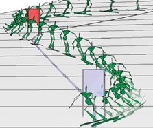
Center of Mass (CoM) trajectory analysis in competitive skiing
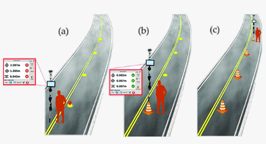
Vehicle performance assessments are governed by strict European and international standards that require extreme precision during track setup. Traditionally, the preparation phase—placing road cones in specific configurations—has been a manual task, often resulting in slow deployment and human error.
The shift toward RTK-integrated track management solves these inefficiencies:
Standardized Accuracy: International standards demand exact spacing and positioning for maneuvers like the “Elk Test” or lane-change maneuvers. RTK provides the centimeter-level precision required to meet these regulatory benchmarks.
Rapid Deployment: Autonomous or guided systems can place track markers in a fraction of the time it takes a human operator, maximizing valuable track time for actual testing.
Repeatability: Digital track layouts stored in the system allow for identical configurations to be recreated day after day, ensuring that data across different test cycles remains consistent and comparable.
Safety & Efficiency: Automating the setup reduces the need for personnel to be on the track during active testing windows, streamlining the entire proving ground workflow.
By digitizing the testing environment with Precision-GNSS, automotive manufacturers and certification bodies can ensure higher data integrity and faster development cycles.
RTK-integrated track management for automotive safety standards
Centimeter-level precision for rapid deployment of test maneuvers
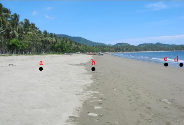
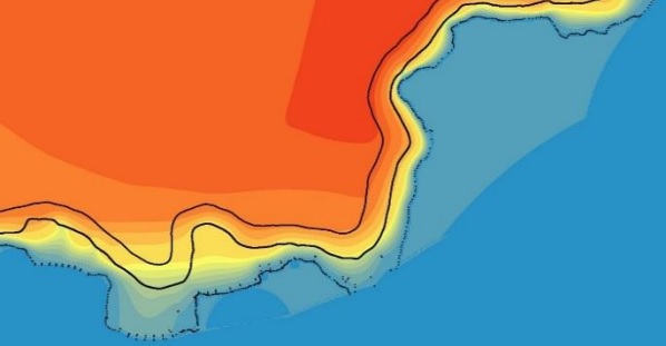
In coastal and marine spatial planning, accurately defining the interface between land and sea is a complex task due to constant tidal fluctuations. GNSS RTK technology provides the high-resolution data necessary to map these dynamic environments with scientific rigor.
How Precision-GNSS facilitates coastal research:
Tidal Datum Reference: By using an RTK Base-Rover Kit, researchers can generate precise coordinates and elevations, using tidal values as a reference datum to determine exact shorelines.
Integrated Elevation Models: Data points are combined with bathymetry and land elevation to create comprehensive Digital Elevation Models (DEM). This allows for the precise calculation of the lowest, highest, and average tide coastlines.
Coastal Morphodynamics: For monitoring cliff erosion and shoreline shifts, the RTK GNSS-Assisted Terrestrial Photogrammetry method offers a breakthrough. By mechanically connecting an RTK antenna to a camera, researchers can georeference imagery with centimeter accuracy.
Efficient Fieldwork: These low-cost, portable systems offer high autonomy, significantly reducing the time required for data acquisition and post-processing compared to traditional surveying.
By leveraging RTK precision, environmental scientists can better predict erosion patterns, plan coastal defenses, and manage sensitive marine ecosystems.
High-resolution data for coastal and marine spatial planning
RTK GNSS-Assisted Terrestrial Photogrammetry for erosion monitoring
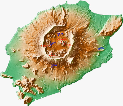
High-precision GNSS RTK technology is an essential tool for measuring geophysical phenomena that occur over both decades and seconds. By providing absolute positioning, it allows scientists to track movements that are often invisible to the naked eye.
The synergy between RTK and traditional geophysics:
Tectonic & Volcanic Activity: RTK can detect the slow drift of tectonic plates—often just a few millimeters per year—as well as the inflation and deflation of volcanoes caused by magma movement.
Landslide Monitoring: On a smaller scale, RTK sensors provide a reliable way to monitor high-risk slopes, providing early warnings when a landslide begins to accelerate.
Earthquake Analysis: While seismometers are highly sensitive to vibrations, they can “clip” or go “off the scale” during massive seismic events. GNSS receivers do not have this limitation; they accurately measure the absolute displacement (the actual distance the ground moved) during a major earthquake.
Complementary Sensors: By combining the sensitivity of seismometers with the wide dynamic range of Precision-GNSS, researchers can gain a complete and accurate picture of seismic magnitude and ground deformation.
For researchers in the fields of geology and glaciology, the ability to detect minute changes in the environment is critical. GNSS RTK technology enables the measurement of permanent ground displacement and ice dynamics with a level of detail that traditional GPS cannot reach.
Key applications for Precision-GNSS in Earth Sciences:
Three-Dimensional Displacement: Unlike standard sensors, RTK allows you to measure movement in all three dimensions (X, Y, and Z) at specific, fixed points on the ground. This is essential for tracking land subsidence or tectonic shifts.
Millimetric Accuracy: When your research requires finding a permanent displacement of just a few millimeters, RTK provides the high-resolution data necessary to validate geological models.
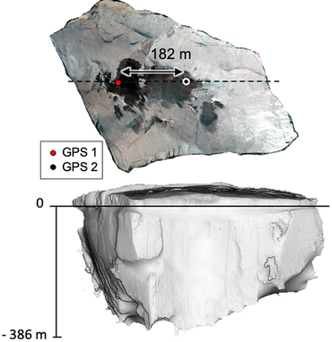
Glaciology and Ice Dynamics: RTK is a powerful tool for measuring the rate at which icebergs melt or for scanning the surface of glaciers. By placing receivers on ice surfaces, researchers can track flow velocities and elevation changes in real-time.
Environmental Scanning: High-precision coordinates serve as the “anchor” for surface scans, ensuring that 3D models of ice formations or terrain are accurately georeferenced for long-term comparative studies.
Absolute positioning for tectonic and volcanic activity tracking
Measuring three-dimensional displacement in geophysical phenomena
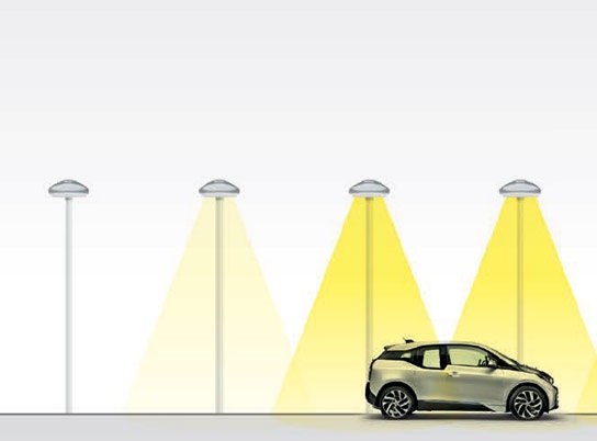
To ensure road safety, street lighting must provide consistent, standardized levels of illumination across the entire carriageway. However, measuring these levels across a precise grid of points has traditionally been a slow and labor-intensive manual process.
The integration of GNSS RTK transforms how urban lighting is audited:
Automated Grid Mapping: RTK technology allows for the rapid and accurate determination of measurement points. Systems can now automatically attribute illumination data to specific “post-measurement fields” with centimeter-level precision.
Geospatial Accuracy: By linking light intensity sensors with Precision-GNSS, every data point is unambiguously tied to its exact location on the road, eliminating errors caused by manual recording.
Detailed Illumination Profiles: Using collected data in conjunction with digital terrain maps, engineers can generate highly detailed profiles of surveyed road sections to identify dark spots or areas of over-illumination.
Versatility & Efficiency: This automated approach increases the versatility of measurement vehicles, allowing them to survey large sections of the city in a fraction of the time required by traditional methods.
By digitizing infrastructure audits, city planners can ensure that public lighting meets rigorous safety standards while optimizing energy consumption.
Automated grid mapping for urban lighting audits
Precision-GNSS for digitized road infrastructure safety profiles
Are you in an industry not listed above and you are not sure if this is the right technology for you?
