The intersection of high-precision satellite positioning and cultural heritage has traditionally been a costly affair, reserved for large-scale excavations with significant budgets. However, a recent paper presented at the IMEKO TC-4 International Conference on Metrology for Archaeology has demonstrated that “low-cost” doesn’t have to mean “low-precision.”
The study, titled “Intensive archaeological survey at Piscina Torta: use of a low-cost RTK portable kit to materialise a UTM grid on the ground,” showcases a workflow that could revolutionize how field archaeologists manage spatial data.
The study was a collaborative effort between two prestigious European institutions:
L. Alessandri (University of Groningen, GIA, The Netherlands)
V. Baiocchi (Sapienza University of Rome, DICEA, Italy)
F. Monti (Sapienza University of Rome, DICEA, Italy)
Their work was conducted within the framework of the Salt and Power project, focusing on an Iron Age site located in the Natural Park of the Pineta di Castel Fusano, Italy.
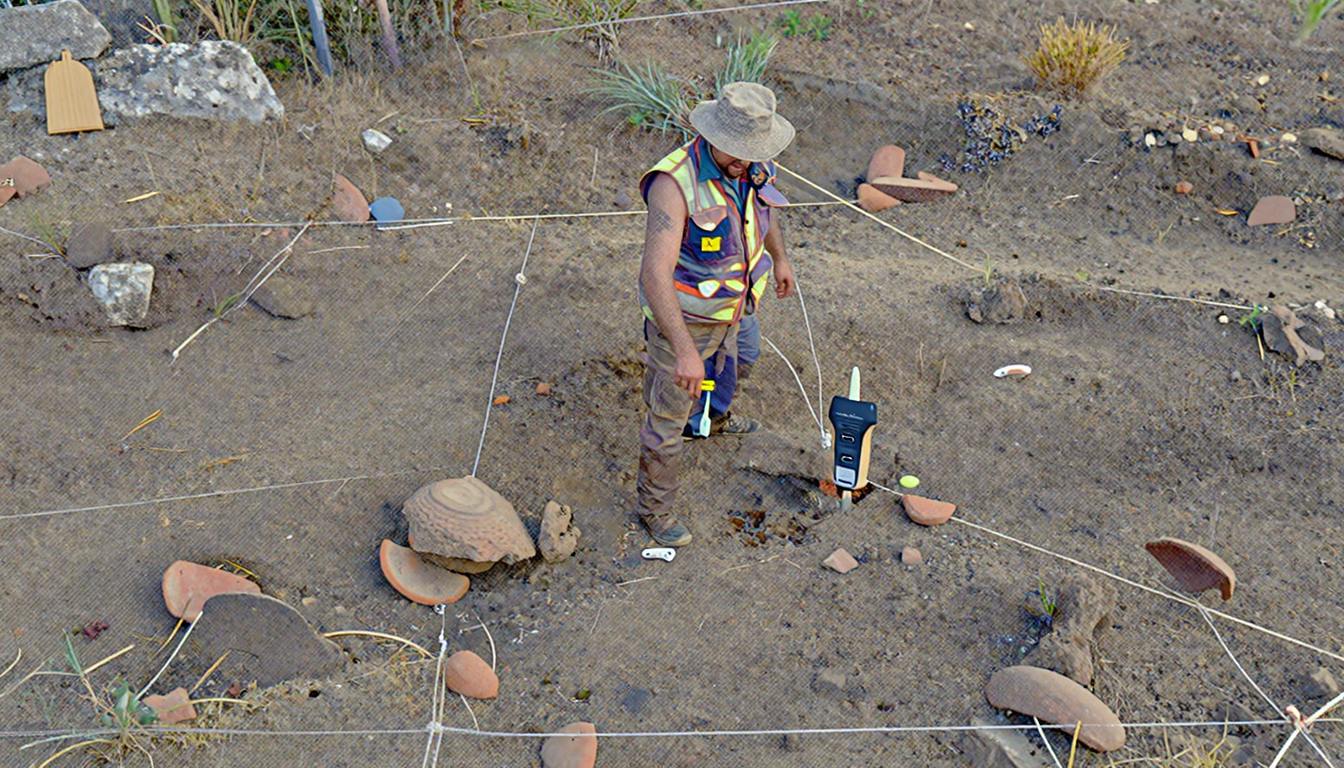
The Piscina Torta site is of immense historical value, characterized by a massive dispersion of potsherds (reddish jars and dolia) dating back to the 7th and 6th centuries BCE. These artifacts are linked to ancient salt production—a “white gold” industry of the Early Europe era.
To map the density of these artifacts accurately, the researchers needed to set up a rigorous 5x5m grid over a 10-hectare surface.
The innovation lies in the “Hybrid Methodology” used to materialise the grid. Instead of relying on expensive total stations or imprecise built-in smartphone GPS, the team utilized a high-efficiency, low-cost kit.
RTK Kit: ArduSimple RTK Portable Bluetooth Kit (using the u-blox ZED-F9P module).
Controller: Samsung Galaxy A52 smartphone.
Correction Service: Free GNSS RTK permanent network from the Lazio Region.
Mapping Apps: SW Maps for signal processing and Epicollect5 for data gathering.
GIS: QGIS 3.22 for the initial grid design in WGS84 UTM 33N.
The team placed “Master Stakes” every 20 meters using the RTK kit. Intermediate stakes were then placed using traditional measuring tapes. This hybrid approach allowed for rapid deployment while mitigating the risks of working under tree cover.
One of the most striking findings was the comparison between the low-cost ArduSimple receiver and professional-grade geodetic equipment (Geomax Zenith 10).
Positional Deviation: The deviation between the planned grid nodes and the actual points re-measured in the field showed a maximum error of only 20 cm, with many points showing deviations of just a few millimeters.
Constellation Advantage: Interestingly, the low-cost kit often outperformed older professional units in dense areas because it could track more constellations (GPS, GLONASS, Galileo, and BeiDou) simultaneously.
Efficiency: The kit allowed for point acquisition in just a few seconds once configured, drastically reducing the time needed to set up a survey site.
|
Feature |
Built-in Smartphone GPS |
Traditional Total Station |
Low-Cost RTK (BOKU Study) |
|---|---|---|---|
|
Accuracy |
10–20 meters |
Centimeter-level |
Centimeter-level (<20cm) |
|
Setup Time |
Instant |
High (Needs georef) |
Low (Direct UTM) |
|
Equipment Cost |
$0 (Existing) |
Very High ($$$) |
Low ($) |
|
Technical Skill |
Low |
High |
Moderate |
The authors propose a significant shift in archaeological data management: abandoning local grids.
By using the WGS84 UTM grid, the team suggested naming each artifact bag based on the coordinates of the North-East (NE) corner of the cell (e.g., Cell 279977, 4621261). This ensures that even if maps are lost, the data remains inherently georeferenced and easily shareable among the global scientific community via platforms like Google Earth.
The study at Piscina Torta proves that high-precision RTK technology is no longer an “elite” tool. By combining low-cost hardware with free correction networks and open-source GIS software, researchers can achieve professional geodetic results.
For the GNSS industry, this highlights a growing market: archaeologists and cultural heritage professionals who need reliability and absolute positioning without the prohibitive costs of legacy systems.
Alessandri, L., Baiocchi, V., & Monti, F. (2022). Intensive archaeological survey at Piscina Torta: use of a low-cost RTK portable kit to materialise a UTM grid on the ground. Proceedings of the 2022 IMEKO TC-4 International Conference on Metrology for Archaeology and Cultural Heritage.
Low-cost RTK Archaeology, ArduSimple GNSS Survey, Piscina Torta Archaeological Survey, UTM Grid Materialization, Precision GNSS Cultural Heritage, ArduSimple u-blox ZED-F9P, Georeferencing Archaeological Sites.
Follow Precision-GNSS.com for more insights on how RTK technology is uncovering the secrets of our past.