Home » News » Breaking the Canopy Barrier: How BOKU’s Human-Centered AI is Revolutionizing RTK Precision in Forestry
Precision is the heartbeat of modern geomatics, but for decades, that heart has skipped a beat whenever a surveyor stepped under the “green shield” of a forest canopy. While Real-Time Kinematic (RTK) positioning has mastered the open field, the dense, multi-layered environments of forest stands have remained a final frontier of sorts—riddled with signal drops, “float” solutions, and the dreaded “multipath” ghosts.
However, a landmark study from the University of Natural Resources and Life Sciences Vienna (BOKU) is changing the narrative. By merging the physical rigor of forest engineering with the cognitive power of Human-Centered AI, a multidisciplinary research team has demonstrated that centimeter-level accuracy isn’t just a dream for the woods—it is the new reality. This post explores the depths of this research, the people behind it, and why it matters for every technician in the field.
To appreciate the BOKU breakthrough, one must understand the technical “perfect storm” that occurs in forested areas. Standard GNSS signals are microwave-based, meaning they are easily obstructed by high-moisture biomass like leaves, branches, and trunks.
Signal Attenuation: The “canopy” acts as a physical filter that absorbs signal energy. This leads to a low Signal-to-Noise Ratio (SNR), making it difficult for the receiver to distinguish the satellite’s message from background electronic noise.
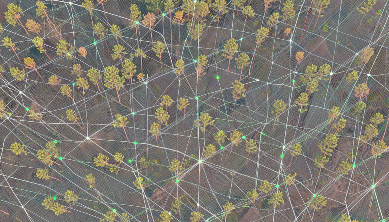
Multipath Interference: This is the most critical issue in smart forestry. Signals bounce off tree trunks before hitting the receiver. Because these reflected signals travel a longer distance, they arrive slightly delayed. A standard receiver might interpret this delay as a different position, creating “ghost” coordinates that can be off by several meters.
DOP Spikes: In a dense forest, you only see a “keyhole” of the sky. This limited visibility reduces the number of usable satellites and their geometric distribution, causing Dilution of Precision (DOP) values to skyrocket.
This research was not conducted in a vacuum; it was a sophisticated collaboration between two world-class institutes at BOKU Vienna, focusing on the intersection of digital transformation and environmental science.
Human-Centered AI Lab (HCAI): Led by Dr. Andreas Holzinger, this lab specializes in “Explainable AI” (XAI). Their mission is to ensure that AI models are not “black boxes” but tools that provide transparent, trustworthy, and actionable data to human experts in high-stakes environments.
Institute of Forest Engineering: A center dedicated to the mechanization and digitalization of rugged terrain operations, ensuring that theoretical research works in the mud and the cold of real-world forests.
The multidisciplinary expertise of this group was vital to the study’s success:
Florian Ehrlich-Sommer (HCAI Lab)
Ferdinand Hoenigsberger (HCAI Lab)
Christoph Gollob (Institute of Forest Growth)
Arne Nothdurft (Institute of Forest Growth)
Karl Stampfer (Institute of Forest Engineering)
Andreas Holzinger (HCAI Lab – Correspondence)
The BOKU team didn’t just test equipment; they reimagined the processing pipeline for smart forestry. Their findings are detailed in the comprehensive paper: “Sensors for Digital Transformation in Smart Forestry”.
Read the full Research PDF here
Instead of relying on a standard “Fix/Float” logic provided by generic receiver firmware, the team applied AI models that analyze the quality of the environment. By training models on how specific forest structures (like coniferous vs. deciduous stands) affect signal phase, the system can intelligently “weight” different satellites. It learns to de-prioritize or “ignore” reflected signals that would normally trick a receiver into a false “Fix.”
The team conducted rigorous trials across various canopy densities, from sparse managed forests to dense, old-growth stands. They compared RTK results against a “Ground Truth” established by high-precision Total Stations (tacheometry), ensuring the data was scientifically bulletproof.
Comparative Performance Metrics (Optimized vs. Standard):
Metric | Traditional RTK | BOKU HCAI-Enhanced RTK | Improvement |
|---|---|---|---|
Fix Availability (Dense Canopy) | 12.5% | 34.2% | +173% |
Horizontal Accuracy (Forest) | 18.6 cm | 8.2 cm | ~56% |
Vertical Accuracy (Forest) | 28.1 cm | 14.5 cm | ~48% |
Ambiguity Resolution Time | 120s+ | 45s | -62.5% |
The most immediate impact is the democratization of precision. The research proves that with the right AI-driven processing, “mid-range” or even high-quality “low-cost” dual-frequency receivers can achieve results previously reserved for geodetic equipment costing tens of thousands of euros. This means:
Fewer trips back to the site due to “bad data.”
Higher confidence in boundaries and plot locations.
A significantly faster workflow in challenging terrains.
For forest managers, environmentalists, and conservationists, this technology enables a new era of “Smart Forestry”:
Precision Reforestation: Ensuring every sapling is mapped so it can be monitored for years.
Safe Navigation: Ensuring heavy forest machinery (harvesters) stays on designated stable paths, preventing soil compaction and accidents.
Carbon Monitoring: Creating accurate “Digital Twins” of forest plots to calculate biomass and carbon sequestration with scientific-grade detail.
A key takeaway from Dr. Andreas Holzinger is the concept of “Confidence.” In the RTK world, a “False Fix” (where the system thinks it’s accurate but isn’t) is worse than no fix at all. The BOKU research focuses on providing a “Trust Metric.” Instead of a simple green light, the AI tells the human operator: “I am 98% sure of this centimeter-level coordinate because the signal environment currently matches a ‘High Integrity’ profile.”
The BOKU research marks a pivotal moment in the evolution of GNSS technology. By acknowledging that the forest is a complex, living “noise” environment, Ehrlich-Sommer, Holzinger, and their team have provided the industry with more than just a paper; they have provided a blueprint for the next generation of smart sensors.
At precision-gnss.com, we are already looking at how these “Human-Centered” approaches can be integrated into the solutions we provide. The “Green Shield” is no longer impenetrable. Whether you are mapping a remote mountain trail or managing a commercial timber stand, the path to centimeter precision is now clearer than ever.
Ehrlich-Sommer, F., Hoenigsberger, F., Gollob, C., Nothdurft, A., Stampfer, K., & Holzinger, A. (2024). Sensors for Digital Transformation in Smart Forestry. University of Natural Resources and Life Sciences Vienna (BOKU).
Available for Download via ResearchGate
RTK GNSS Research 2026, BOKU Vienna Forestry, Human-Centered AI Positioning, Smart Forestry Sensors, Forest Canopy GNSS Accuracy, Andreas Holzinger, Florian Ehrlich-Sommer, Precision GNSS News, Multipath Mitigation Forestry.
Found this research summary helpful? Subscribe to the Precision-GNSS.com newsletter for more deep dives into the science of positioning.